

Community-based coastal monitoring in the Pacific
Community-based coastal monitoring in the Pacific was seen to be a highly suited approach that could meet the needs for coastal monitoring and management. Workshop participants gained the conceptual and technical know-how to install monitoring stations as part of their R2R Project on the return to their home locations. More information on the lessons learned and methods of replication are contained within this twinning report.
Coastlines are dynamic environments. To be effectively managed, coastal erosion events are needed to be understood within broader cycles of sediment erosion and replenishment. In order to understand these processes monitoring is needed to measure the coastline over time. This traditionally requires significant resources to survey the coast. The tyranny of distance makes on-the-ground surveys even more of an investment in the Pacific with both air and sea travel frequently required. This Twinning Workshop shared the experience in Australia of CoastSnap, an innovative community-based beach and coast monitoring program, provides low-cost effective beach and coastal processes monitoring. Originally developed at the University of New South Wales (UNSW), CoastSnap has been successfully deployed in Australia, New Zealand, Africa, Europe, Central and South America. The LME:LEARN-funded Twinning Workshop saw the sharing of issues of coastal management and monitoring in PICs and the erection of the first-ever CoastSnap station in the Pacific.
| Meta data | |
|---|---|
| Regions | Oceania , SIDS (Oceania) |
| Scope | Regional |
| Ecosystem | Coastal |
| Categories | Large Marine Ecosystem |
| Thematic | Coastal Management , Workshop |
Participants (Appendix 1) from Pacific Ridge to Reef (R2R) projects attended the four-day workshop (Appendix 2) in Suva, Fiji. The workshop was generously hosted by The Pacific Community and funded under the LME:LEARN Twinning Program. The workshop served two purposes:
- The Projects were able to share and discuss areas of erosion concern and monitoring priority amongst each other and develop proposed monitoring locations with expert input from UNSW on site selection and design.
- The Projects took part in the installation of a monitoring station and experienced firsthand the optimal station placement, local surveying and geospatial data collection, cradle/hardware installation, signage and community awareness activities.
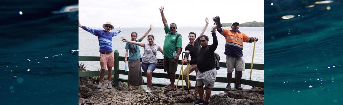
The workshop saw participants share the coastal monitoring capabilities and needs from their countries and hear about some of the coastal monitoring approaches pioneered at UNSW. The CoastSnap monitoring approach was the focus of the workshop and the group travelled up the Coral Coast to install the first Pacific Island CoastSnap station. In partnership with the Pacific Community and with the help of all participants, the station was installed at the Shangri-La’s Fijian Resort on Yanuca Island. The partnership and support of the Shangri-La in embracing it into their impressive community engagement, environmental awareness, ocean monitoring and school education initiatives is of major benefit to the CoastSnap initiative. The workshop trained the participants to plan, install and manage their own monitoring stations on the return to their home locations, with UNSW experts available for advice and input remotely as needed. A Tongan CoastSnap station is looking to be the next implemented through the Tongan Department of Environment.
Sharing of experience and knowledge exchange between the Projects allowed common challenges and opportunities to be identified on the issue of coastal erosion and sediment transport. The key lessons learned are:
Coastal Protection is a Priority - Degradation of coastal zones and climate change were conveyed by the R2R projects as the most important issue in Pacific. Some countries have almost been completely covered by sea walls. Because decision makers most often do not consider the natural cycles of sediment transport (erosion and replenishment) the solution if often engineering-focussed. Once the sea walls are built there is no monitoring or data collection and as such, no data to look at the impact and effectiveness of seawalls.
Coastal monitoring gap – There is a lack of monitoring due to cost, resources and technical ability is a common issue in the Pacific. In Samoa nothing is currently being done to monitoring coastlines. Biodiversity is monitored but not coastal monitoring. Similarly, in Tonga, the aquatic and terrestrial species that live within the local area is monitored, alongside water salinity, but monitoring of changes to the coastal area is not done.
Coastal monitoring need – Changes in the physical extent of coastline are happening with both impacts from upstream activities and the ocean are suspected. Sand mining in the upstream stretches of the river saw many monitoring policies waived but this is changing the sediment transport mechanisms of the river. The number and spatial extent of native species are being monitored upstream. In Tonga a a sediment trap using coconut husk was about to be constructed and community engagement combined with monitoring would allow its effectiveness to both be measured and better communicated.
Combine coastal monitoring with biodiversity monitoring – Biodiversity monitoring was something that was already in place as part of the R2R approach in the PICs. Upstream riverine activities, most notably sand and gravel mining in the river beds, were the reason for this monitoring to identify downstream ecological impacts of increased river sedimentation. It would make sense to align coastal monitoring efforts with biodiversity and salinity monitoring efforts.
Engagement with private landholders – Large resort hotels often occupy prime coastal land with scenic vantage points ideal for visually monitoring coastline. Engagement with these private land holders/leasers is likely to be successful die to the importance of natural beauty, rich biodiversity and usable beaches to the tourism industry. This requires engagement of the hotel guests to use the CoastSnap site. This has proved ineffective at the Shangri-La and an onsite staff member who champions the project and prizes for users have been suggested improvements.
Community engagement – Community engagement and discussion prior to any monitoring effort was stressed. The example of identifying a one female and one male champions from the local community was highlighted based on successful engagement with local communities in Samoa. Facebook statistics available from each community-member upload allow demographic information on who is engaging in the community monitoring to be gathered, such as age and gender.
Community-based coastal monitoring in the Pacific was seen to be a highly suited approach that could meet the needs for coastal monitoring and management. Workshop participants gained the conceptual and technical know-how to install monitoring stations as part of their R2R Project on the return to their home locations. UNSW remains available for advice and input remotely as needed and shared all of the technical documentation via a shared google drive with participants.
To facilitate additional CoastSnap station installations in the Pacific. The following outcomes were achieved:
- Projects now able to lead the installation of monitoring stations in their respective countries/regions of R2R implementation, including:
- Identify suitable locations.
- Plan and implement geospatial data collection in the area of coastal monitoring to allow the shoreline detection technology to be implemented.
- Hardware installation (installation of cradle)
- Management of data and social media portals
- Projects able to seek advice from UNSW to manage data and generate short, medium and long term trend data for coastal processes and major erosion/replenishment events.
- Knowledge shared of coastal vulnerability hotspots and common issues in R2R partner countries.
Some small funds are needed to construct the CoastSnap station (~ AUD $1500 in Australia, cheaper if constructed in R2R countries and UNSW can share design documents) and the initial surveying of the coast to be monitored. Options for this were discussed and included:
- Regional R2R support as part of the state of environment intuitive across 12 countries.
- Costing as part of R2R extension requests. This option is highly suited to bridge existing biodiversity monitoring efforts with habitat and coastal monitoring, for example where river mouth and mangroves are part of the dynamic coastline being monitored.
- River mouth monitoring provides a good indicator of the health of the catchment and sediment levels (build-up/depletion) would provide information on coastal processes but also effectiveness of upstream revegetation efforts combating erosion.
- Sites where R2R Regional Project is undertaking Rapid Coastal Assessments, these long term assessment sites make sense to host a CoastSnap station, up to 14 sites if all national sites undertaken in rapid assessment.
The twinning exchange also empowered the Projects to install their own monitoring stations on the return to their home locations with UNSW available for advice and input remotely as needed. Refer to Table 1 for specific considerations for suitable sites.
APPENDIX 1 – Workshop Participants
| Person | Project | Notes |
|---|---|---|
| Pauline Pogi | Samoa Ministry of Natural Resources and Environment / GEF Pacific R2R Project | Attended |
| Eti Malolo | Samoa GEF Pacific R2R Project | Attended |
| Iliesa Tora | Tonga R2R Project | Attended |
| Beverly Sadole F | Fiji R2R Project | Apologies |
| Mataio Tekinene | Previous Tuvalu R2R, currently in Suva | Apologies |
| Rosalinda Yatilman | FSM R2R Project | Apologies |
| Phaedora Harris | Nauru R2R Project | Apologies |
| Louisa Karika | Cook Islands R2R Project / National Environment Service | Apologies |
| Emma Newland | SPC | Attended |
| Sarojini Devi | SPC | Attended |
| Mitch Harley | UNSW Water Research Laboratory | Attended |
| Andrew Dansie | UNSW Global Water Institute | Attended |
APPENDIX 2 – Workshop Agenda
GEF Large Marine Ecosystem: Learning Exchange and Resource Network (LME:LEARN)Twinning Workshop
Date: Suva 27 Jan – 31 Jan 2019 Venue: SPC Geoscience Division, 241 Mead Road, Suva, Fiji
Monday 28th Jan – 10:00 start at SPC Geoscience Division
10:00 – 10:15 Introductions around the room (all)
10:15 - 12:15 CoastSnap as an effective tool for coastal monitoring – lessons learned from Australia and examples of ongoing monitoring efforts (MHarley)
12:15 – 13:15 Lunch
13:15 – 15:30 R2R project sharing of coastal management needs and vulnerable areas (presentation of costal monitoring needs and interactive walk-throughs using satellite image) (all)
15:30 – 15:45 Afternoon tea break
15:45 – 17:00 Preparation for site visit: site selection, suitability of the technology for different parts of the coast and geospatial planning (MHarley)
Tuesday 29th Jan – Early departure from Suva via road. Time and pick up point TBC
All day site visit to Shangri-La to meet and discuss with Shangri-La representatives *please bring water and suitable attire for spending time walking* Lunch will be at Shangri-La Hotel
Wednesday 30th Jan - Early departure from Suva via road. Time and pick up point TBC
All day site visit to Shangri-La for hardware and signage installation at CoastSnap monitoring station location and surveying of monitoring area.
Thursday 31st Jan – 09:00 at SPC Geoscience Division
09:00 - 10:30 Processing of surveying data and management of online portal.
10:30 – 10:45 Morning tea break
10:45 - 12:30 Using Adobe Photoshop and Adobe Premier Pro to process photos from Shangri-La site
12:30 – 13:30 Lunch
13:30 – 15:30 Discussion and feedback on each R2R Projects’ proposed CoastSnap locations
15:30 – 16:00 Afternoon tea
16:00 – 17:00 CoastSnap data to generate short, medium and long term information on coastal processes.
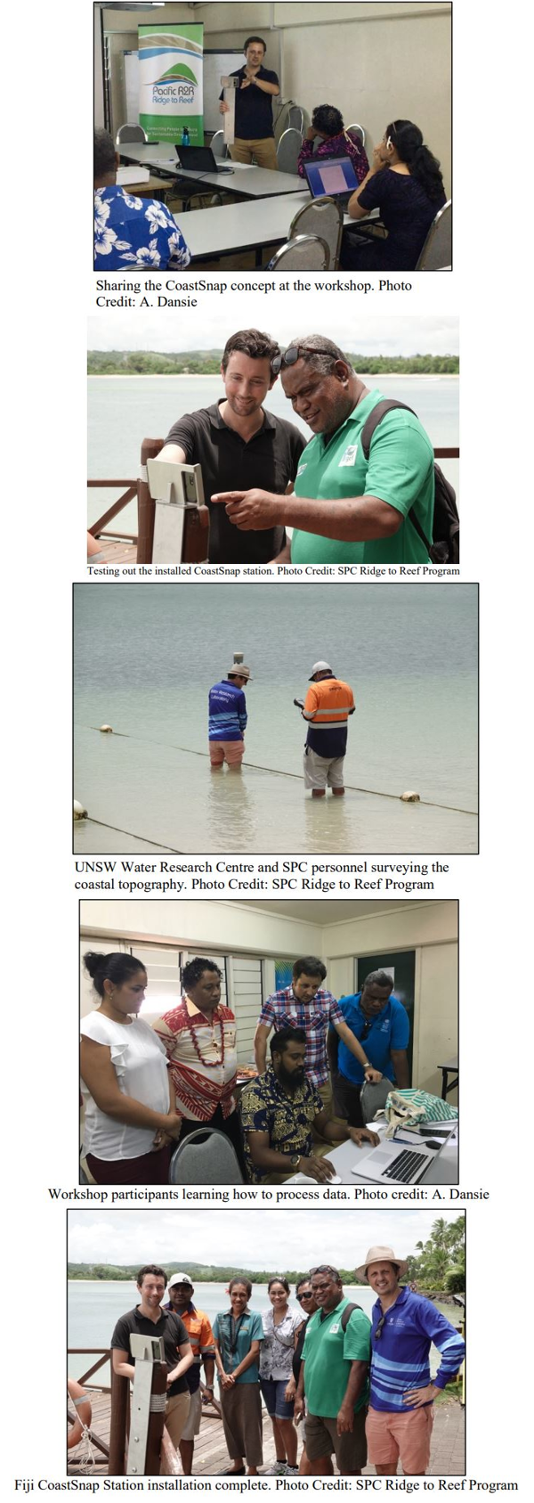
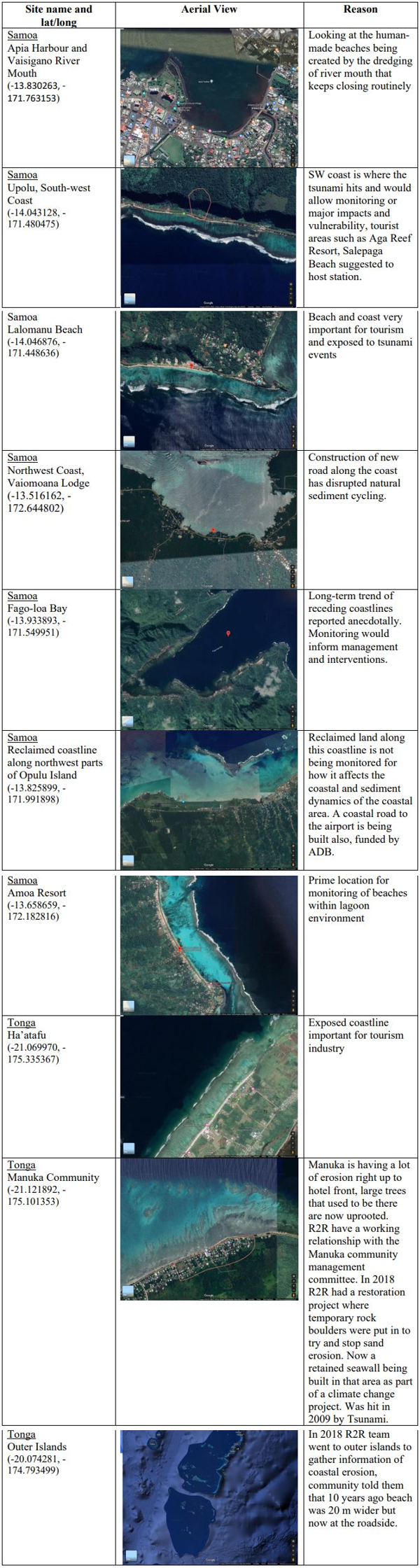
Table 1. Specific considerations for suitable sites


