

Vulnerability Mapping: Karst Aquifers in Croatia
Karst aquifers are an important source of groundwater worldwide. They are particularly vulnerable to pollution and there is a need to increase knowledge and raise awareness about the link between land-based activities and the quality of groundwater in these aquifers. In many cases, discharges from karst aquifers introduce significant volumes of freshwater to the marine environment. Two case studies were undertaken in Croatia to assess and map the vulnerability of karst aquifers in coastal areas. The first of these case studies (Pula coastal aquifer) tested four commonly-used methodologies for assessing aquifer vulnerability to determine which was best suited to karst aquifers. The second case study (Novljanska Zrnovnica karstic spring catchment area) built on the experience of existing methodologies for aquifer vulnerability assessment and developed a new methodology specifically adapted to the karst environment. The results of these case studies provide practical examples to groundwater managers in other karstic regions (in the Mediterranean and beyond) that are seeking guidance on evaluating vulnerability of karst aquifers to pollution from land-based activities.
The objective of this activity was to increase knowledge about the vulnerability of coastal karst aquifers to pollution from land-based activities. Since these types of aquifers have the potential to transmit significant volumes of freshwater (and potentially pollutants) to the Mediterranean Sea, it is important for countries to have tools that can enable them to make informed decisions concerning the use of land affecting the quality of groundwater in coastal aquifers. The anticipated outcomes of this activity included aquifer vulnerability maps for the two case study locations, an analysis of the suitability of four standard aquifer vulnerability assessment methodologies to the karst environment, and management recommendations for policy makers in the case study areas. These outcomes are captured in the final reports and vulnerability maps provided by the Croatian Geological Survey and the University of Zagreb’s Faculty of Geotechnical Engineering, the institutions with which UNESCO-IHP collaborated on this activity over the course of 18 months.
Appropriately managed coastal aquifers in the Mediterranean can supply fresh groundwater for sustaining human livelihoods while also contributing positively to the health of the transboundary Mediterranean Sea ecosystem. Humans depend on high quality groundwater resources for drinking water, irrigation, tourism and other activities, while discharges of groundwater from coastal aquifers to the Mediterranean Sea are critical to the water balance and to maintaining good seawater quality.
In spite of this, groundwater remains a largely invisible resource, and this lack of visibility can often contribute to uninformed management decisions that result in the overexploitation or pollution of groundwater resources. Unchecked consumption of groundwater resources can drive down water tables and lead to seawater intrusion in coastal aquifers, rendering the groundwater unsuitable for drinking or other uses. Meanwhile, degradation of coastal aquifers can also occur when pollutants from human activities infiltrate the soil and subsoil covering the aquifer and contaminate the groundwa-ter below. Since most coastal aquifers in the Mediterranean are in hydraulic communication with the Sea, there is also the potential for discharge of contaminated groundwater to the Sea.
Ensuring a long term, reliable supply of high quality groundwater therefore depends on sustainable consumption to reduce the risk of seawater intrusion from lowering water tables, but also on measures to protect aquifers from human ac-tivities that may pollute underlying groundwater resources. For this, hydrogeologists must be able to communicate effec-tively with decision makers about the degree to which an aquifer is vulnerable to pollution. Vulnerability mapping is one tool that can facilitate this communication.
What is vulnerability mapping?
Vulnerability mapping is a tool that illustrates the location and severity of risk to which a system is subject. When applied to coastal aquifers, this tool can be used to indicate areas of an aquifer where there is a threat of pollution of groundwater from land-based activities. The threat of pollution is estimated based on models that consider parameters such as the nature of soil cover, the sub-soil conditions and the type of aquifer. The resulting maps can be valuable aids in the development of groundwater protection strategies, for example the establishment of sanitary protection zones for drinking water sources, or environmental and urban planning policies that fully consider the presence and vulnerability of groundwater resources.
UNESCO-IHP undertook three pilot projects to demonstrate the use of vulnerability maps to visually represent the vul-nerability of coastal aquifers to contamination from land-based sources and the intrusion of seawater. The value of these maps stem from their ability to raise the visibility of groundwater resources and the relative ease with which they can communicate complex hydrogeological data to decision makers that are responsible for land use planning and resource management.
The pilot projects considered vulnerability of these aquifers in strictly hydrogeological terms, without reference to the properties of individual contaminants. This approach is commonly referred to as ‘intrinsic’ or ‘natural’ vulnerability. Conversely, vulnerability that accounts for the behavior of particular pollutants is referred to as ‘specific’ vulnerability.
Rationale for selection of pilot projects
Croatia – a country characterized by the widespread pres-ence of karst terrains - was the setting of two of the vulnerability mapping pilot projects. The first, undertaken by the University of Zagreb Faculty of Geotechnical En-gineering, considered the Novljanska Zrnovnika karstic spring catchment area. The second, implemented by the Croatian Geological Survey, focused on the Pula coastal karst aquifer.
Box 1 – Vulnerability of karst aquifers
Worldwide, groundwater from karst aquifers is consid-ered an important resource and is widely used for drinking water. In Europe, for example, karst terrains occupy nearly 35% of the land surface and in some countries karst groundwater supplies up to 50% of the total drink-ing water; in many regions, it is the only available fresh-water source. Karst aquifers are particularly vulnerable to contamination due to thin soils or absence of covering deposits, flow concentration within the epikarstic zone and concentrated recharge via swallow holes. As a re-sult, contaminants may easily reach the groundwater and be transported in karst conduits over large distances.
Methodology
Groundwater vulnerability mapping methods tested
A total of four existing aquifer vulnerability mapping methodologies were applied in the context of the two case studies:
- The PI method (Goldscheider et al., 2000; Goldscheider, 2002), based on the assessment of the intrinsic vulnerability of aquifers using cover characteristics (P) and the conditions of the surface water infiltration (I).
- The COP method (Vias et al., 2002), which considers the characteristics of covering layer (A), the concentration of surface water flow (C) and precipitation data (P).
- The SINTACS method (Civita and De Maio, 2000), a method similar to the DRASTIC method since it uses almost the same parameters: depth to groundwater (S), surface water infiltration (I), properties of the unsaturated zone (N), properties of the cover layers (T), properties of the saturated zone of the aquifer (A), hydraulic conductivity of the layers (C), and terrain slope (S). Unlike DRASTIC, however, this method uses weighted parameters that allow users to adapt it to different hydrogeological conditions.
- The European Approach (developed in the framework of the European COST Action 620 Project, 2004), a method that provides guidance on evaluating and accurately defining the parameters that should be used when assessing the natural vulnerability of karst aquifers.
Additionally, the University of Zagreb Faculty of Geotechnical Engineering built upon these experiences by developing a new methodology specifically adapted to karst terrains, the Karstic Aquifer Vulnerability Assessment method (the KAVA method).
Overview of KAVA methodology
The KAVA method is a multi-parameter GIS method that builds on the good practices of existing methodologies and incorporates new parameters to take into account the unique nature of karst terrains. It is based on a conceptual model origin-pathway-target (COST 620, 2004). Natural vulnerability is assessed using four basic factors: overlay protection (O), precipitation influence (P), infiltration conditions (I), and aquifer conditions (I).
The considerations developed in the KAVA model to better reflect conditions in karst terrains include:
- Assigning maximum vulnerability to areas with sinkholes, sinkhole zones and surface water bodies affected by them, regardless of the vulnerability estimates obtained from the other parameters;
- The protective role of soil cover is modified so that it is directly dependent on the parameters related to the impact of extremely karstified and permeable surface and upper zones of karst aquifers, particularly on the development and presence of epikarst zones;
- When assessing the impact of infiltration on the natural vulnerability of karst catchments, the conditions on the ground surface (slope and vegetation) have been updated with the parameter ‘influences of the depth to groundwater’ because the impact of surface water will be lower on deeper water tables; and
- Unsaturated and saturated zones of karst aquifers are treated together since the data necessary to characterize them separately is expensive to obtain.
These resulted in the creation of two new indexes of vulnerability:
- SV index (source vulnerability index) which relates to the assessment of the natural vulnerability of karst springs (source vulnerability); and
- RV index (resource vulnerability index) which relates to the assessment of natural vulnerability in karst aquifers (resource vulnerability).
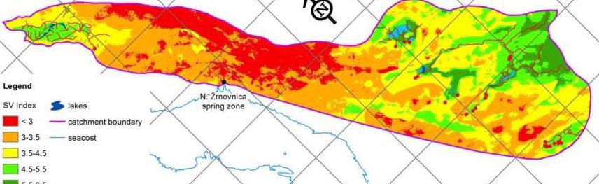
The pilot project at the Novljanska Zrnovnika karstic spring catchment area first tested four existing groundwater vulnerability mapping methods most commonly used for karst terrains (PI, COP, SINTACS and the European Approach). Then, an analysis was undertaken to identify the problems encountered when applying these method to karst terrains. These mainly related to the relationship between the criteria and available data which in karst areas in the Mediterranean are very poor due to the large depths to groundwater and the high degree of heterogeneity of karst aquifers. Based on the results of this analysis, a new method was developed called the Karst Aquifers Vulnerability Assessment (KAVA) method which is primarily aimed at assessing the intrinsic (natural) vulnerability of catchments and springs in karst terrains.
The pilot project at the Pula coastal aquifer, similarly, tested the applicability of two existing groundwater vulnerability mapping methods, SINTACS, and COP. Three weighting strings were used for the SINTACS method: one for karst terrain, one for fissured terrain, and a new “Pula” string adjusted to the local conditions. Among these, it appears that the string for karst terrains yielded the best vulnerability map. Following an analysis of the results of the COP method, it can be concluded that this method is best suited to terrains with pronounced differences in elevation and rock formations.
The results of the intrinsic vulnerability mapping carried out here indicate that most of the Pula coastal aquifer is subject to ‘high’ to ‘very high’ vulnerability. The SINTACS method proved to be a good tool at this site, due to the adaptability of the model to different data availability and local hydrogeological conditions.
In addition to the distinction between natural and specific vulnerability, another nuance is possible when considering resource and source protection. In this case, there are two types of vulnerability mapping: aquifer vulnerability mapping involving resource vulnerability, and individual sources (water supply springs and wells) vulnerability mapping involving source vulnerability. The resource vulnerability includes the processes of contaminant transport through unsaturated zone to the aquifer, while source vulnerability additionally takes into account the contaminant transport through the aquifer to the sources. Within this project, the Pula karst aquifer was considered as the single resource, while individual wells and springs were not considered separately since they are scattered over the almost entire study area.
The KAVA method developed in the context of the pilot project at the Novljanska Zrnovnika karstic spring catchment area could be used in karstic terrains throughout the Dinaric karst region. This type of karst can be found mainly in European countries in the northern part of the Mediterranean region (France, Italy, Slovenia, Croatia, Bosnia and Herzegovina, Montenegro, Albania, Greece, etc). The KAVA method could also be applied in other parts of the Mediterranean region, with additional testing. As with all models, a potential challenge for the replication of the KAVA methodology is the availability of data.
The results of the pilot project carried out at the Pula coastal aquifer highlighted the need for careful consideration of the model used to map the vulnerability of groundwater resources; this choice will be influenced by the available data and the natural characteristics of the study area. Care must be also used when interpreting the resulting maps, since these can be used to establish restrictions of certain activities, in an attempt to protect areas of the aquifer that are most vulnerable to land-based pollutants. In other words, certain socio-economic consequences should be anticipated and fully analyzed.
A regional training workshop was organized in February 2015 in Varazdin, Croatia at the University of Zagreb Faculty of Geotechnical Engineering. The purpose of the workshop was to disseminate results of these case studies to the other countries participating in the MedPartnership project. The training brought together experts from nine Mediterranean countries and provided step-by-step instructions on the establishment of aquifer vulnerability maps.
The significance of these case studies is their demonstration of the use of vulnerability mapping as a tool to communicate information about groundwater vulnerability to planners and decision makers that are generally not familiar with geology and hydrogeology. The main advantage of these maps is that they combine a large amount of highly specialized data and parameters that describe the natural features of the study area (geological, hydrogeological, hydrological, etc.) and transform this information into easily understood maps with clearly stated levels of threat (categories, classes, etc.).
REFERENCES
CIVITA, M. & DE MAIO, M. (1997, 2000): SINTACS R4, R5 a new parametric system for the assessment and automatic mapping of ground water vulnerability to contamination. Pitagora Editor, Bologna, 226 p.
DORFLINGER, N. & ZWAHLEN, F. (1999): Groundwater Vulnerability Mapping in Karstic Regions (EPIC). Practical Guide. SAEFL, 56 p., Bern.
DORFLINGER, N., JEANNIN, P.Y. & ZWAHLEN, F. (1998): Water vulnerability assessment in karst environments: a new method of defining protection areas using multi-attribute approach and GIS tools (EPIK method). Env. Geol. 39/2, 165-176.
GOLDSHEIDER, N. (2002): Hydrogeology and Vulnerability of Karst Systems – Examples from Northern Alps and the Swabian Alb. Schr. Anew. Geol. Karlsruhe, 68, 1-236, Karlsruhe.
GOLDSCHEIDER, N., KLUTE, M., STURM, S. & HOTZL, H. (2000): The PI method – a GIS based approach to mapping ground-water vulnerability with special consideration of karst aquifers. Zeitschrift für angewandte Geologie, 46/3, 157-166.
MALIK, P. & ŠVASTA, J. (1999): REKS – an alternative method of karst groundwater vulnerability estimation. Proceedigs of 29th Congres of the IAH “Hydrogeology and Land Use Management”, 79-85, Bratislava.
NGUYET, V. T. M. & GOLDSCHEIDER, N. (2006): A simplified methodology for mapping groundwater vulnerability and con-tamination risk, and its first application in tropical karst area, Vietnam. Hydrogeology journal 14/8, 1666-1675.
RAVBAR, N. & GOLDSCHEIDER, N. (2007): Proposed methodology of vulnerability and contamination risk mapping for the protection of karst aquifers in Slovenia. Acta carsologica 36/3, 397-411.
VIAS, J. M., ANDREO, B., PERLES, M. J., CARRASCO, F., VADILLO, I. & JIMENEZ, P. (2006): Proposed method for ground-water vulnerability mapping in carbonate (karstic) aquifers: the COP method. Hydrogeology Journal 14/6, 912-925.
VRBA, J. & ZAPOROZEC, A. (1994): Guidebook on Mapping Groundwater Vulnerability. UNESCO/International Association of Hydrogeologists, International contributions to hydrogeology, Hannover, Vol 16, 131 p.
ZWAHLEN, F. (ed.) (2004): COST action 620. Vulnerability and Risk Mapping for the Protection of Carbonate (Karst) Aquifers. Final report COST action 620. Brüssel, Luxemburg, European Commission, Directorate-General for Research, 297.
- Lorenzo Paolo Galbiati (lorenzo.galbiati@unepmap.gr)
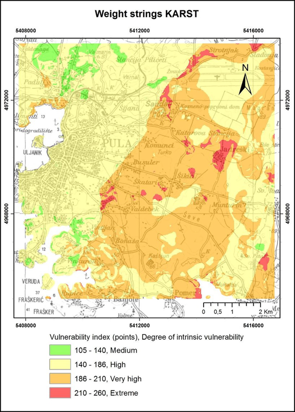
Image 1. Aquifer vulnerability assessed at the Pula coastal aquifer with the SINTACS method and using the karst weighting string, prepared by the Croatian Geological Survey.
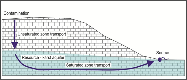
Image 2. Contamination transport model – concept of resource and source protection
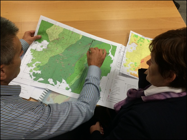
Image 3. Mladen Kuhta of the Croatian Geological Survey explains the different vulnerability grades of the Pula coastal aquifer to Ljiljana Dravec of Istra County, one of the government officials responsible for management of the Pula aquifer.


