

Aquifer vulnerability mapping: Evaluating simultaneously an aquifer’s vulnerability to land-based pollutants and saltwater intrusion
This study was conducted on the coastal aquifer of Ghar El Melh in Tunisia where the aquifer’s vulnerability was evaluated by applying a new, experimental method called Aquifer Comprehensive Vulnerability Mapping (ACVM). This method establishes a single parameter called “comprehensive vulnerability” that describes simultaneously an aquifer’s "vertical vulnerability” linked to contamination threats from land-based pollution, and its "horizontal vulnerability” related salt water intrusion.
An additional vulnerability aspect that was incorporated in the ACVM method is the potential impact on groundwater quality due to the variation of sea levels and the resulting increase in vulnerability to seawater intrusion. Therefore, the ACVM method can be used to establish a map that identifies the parts of an aquifer that are more or less vulnerable to global climate change.
Moreover, the ACVM method can incorporate many aspects of aquifer vulnerability describing all them using only one parameter so ACVM can be a valuable tool for stakeholders and for territory planning in the short and long terms.
The ACVM method was applied in the Ghar El Melh area in Tunisia in the context of the GEF/UNEP-MAP Strategic Partnership for the Mediterranean Sea Large Marine Ecosystem (MedPartnership). UNESCO’s International Hydrological Programme is responsible for the execution of MedPartnership Sub-component 1.1 on “Management of Coastal Aquifers and Groundwater”.
The coastal aquifer in the Ghar El Melh area – like most Mediterranean coastal aquifers – is subject to contamination from both land-based sources and salt water intrusion. Throughout the area, there are many human activities that have the potential to discharge pollutants into the environment which can then infiltrate into groundwater resources.
Groundwater resources in coastal aquifers are often under heavy pressure from intense touristic, industrial, and agriculture activities along the coast. In many cases, drinking water in these areas is supplied partially or wholly by groundwater, which can be degraded by pollution from land-based activities and intrusion of seawater.
Moreover, sea level rise, due to climate change, can have a negative impact on coastal aquifers quality submerging areas near the shore line and increasing the level of the water table.
Comprehensive assessment of aquifer vulnerability
For our purposes, we define aquifer vulnerability as an intrinsic characteristic of the aquifer that describes the natural defences from an external threat such as a pollutant or a contaminant.
Coastal aquifers, like all aquifers, are vulnerable to contamination from infiltration of pollutants from land-based activities (vertical vulnerability). Unlike other aquifers, however, coastal aquifers are also subject to the threat of salt water intrusion, if there is a hydraulic connection between the aquifer and the sea (horizontal vulnerability).
Usually, vertical vulnerability is evaluated separately from horizontal vulnerability, but in coastal areas the two phenomena are linked. In fact, salt water can heavily influence the chemical reaction between pollutants and rocks and the reactions between pollutants themselves.
There are currently many methods for studying vertical vulnerability, but no methods for studying horizontal and vertical vulnerability at the same time. Therefore, in coastal aquifers it is necessary to consider a new, wider concept of vulnerability, a sort of “comprehensive vulnerability” that simultaneously considers these two aspects of aquifer vulnerability.
For that reason, the new ACVM methodology is an innovative approach that incorporates both vertical and horizontal vulnerability in a single parameter called "comprehensive vulnerability" that can then be used to establish a map that illustrates this parameter.
Furthermore, coastal aquifers are vulnerable to climate change, and in fact a modest increase in sea levels can result in significant salt water intrusion and consequently, an increase in an aquifer’s comprehensive vulnerability. The ACVM method can incorporate many aspects of aquifer vulnerability and describe them with a single parameter, which can be used to study the potential impact on groundwater quality due to the variation of sea levels and the resulting increase in “comprehensive vulnerability”.
The new ACVM methodology encompasses:
- A new methodology for mapping horizontal vulnerability associated with salt water intrusion;
- A new methodology for merging vertical and horizontal vulnerability in order to map “comprehensive vulnerability" in coastal areas; and
- A new methodology for evaluating the potential impact on groundwater quality due to the variation of sea levels and the resulting increase in vulnerability from land-based activities and seawater intrusion.
The innovative aspect of ACVM methodology lies in its ability to provide vulnerability map with a visual representation of an aquifer’s vulnerability to several types of external threats, by establishing a cumulative parameter called comprehensive vulnerability.
Comprehensive vulnerability mapping is a new tool that uses a single parameter to simultaneously describe the many aspects of aquifer vulnerability. In the Ghar El Melh area we incorporated in one single parameter the vulnerability of an aquifer to pollution from land-based activities (vertical vulnerability), to salt water intrusion (horizontal vulnerability) and to sea level rise due to climate change.
Consequently, the comprehensive vulnerability map can be a valuable resource for land use and water resources management, since it provides a visual representation of an aquifer’s vulnerability to those types of threats that can have a negative potential impact on groundwater quality.
The comprehensive vulnerability map is based on the information contained in the individual vulnerability maps associated with it. Consequently, it is important to consider all the individual maps when viewing the comprehensive vulnerability map, in order to understand which component of vulnerability is prevalent.
This methodology is easy to use and can be applied with inexpensive data. The accuracy of the results will of course be linked to the quality of the data available. Vulnerability maps established with the ACVM method can be a valuable tool for sound territory planning and for safeguarding the environment and groundwater resources against pollution and overexploitation in the short and long terms.
ACVM method is a new tool that uses a single parameter to simultaneously describe the many aspects of aquifer vul-nerability. In this study we incorporated in one parameter the vulnerability of an aquifer to pollution from land-based activities (vertical vulnerability), from salt water intrusion (horizontal vulnerability) and from sea level rise.
Consequently, the resulting map can be a valuable resource for land use management, since it provides an immediate visual representation of aquifer’s vulnerability to several different threats that can have a negative potential impact on groundwater quality.
The presentation of this information allows stakeholders to easily identify the areas where human activities should be regulated to avoid pollution of groundwater or salt water intrusion in the aquifer while also considering climate change.
Finally, the ACVM methodology developed for mapping the ‘comprehensive vulnerability’ of this system is a new concept and could be replicated at other Mediterranean coastal aquifers.
REFERENCES
Carrubba S., Lagod M. and Stephan R. (2015), "ACVM (Aquifer Comprehensive Vulnerability Mapping) a new method for evaluating coastal aquifer vulnerability", 25-29 May 2015, Ustron, Poland.
www.geoprospezioni.it/ACVM
- Lorenzo Paolo Galbiati (lorenzo.galbiati@unepmap.gr)
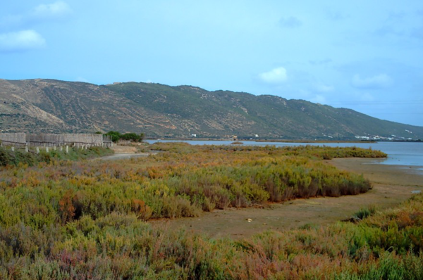
Image 1. The Ghar El Melh coastal area in Tunisia. Credit: Salvatore Carrubba, 2015
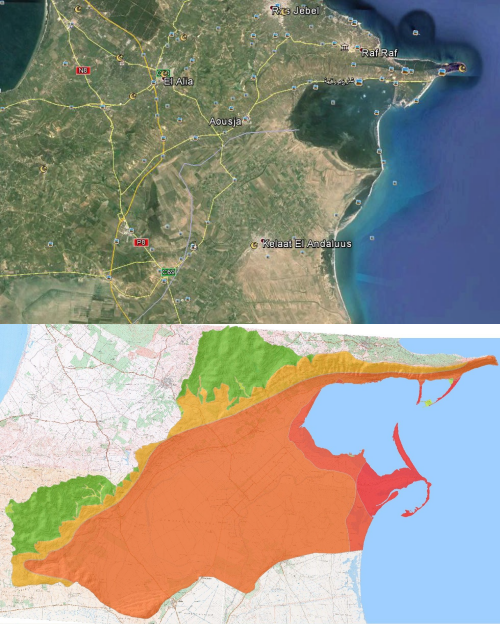
Image 2. Ghar El Melh Coastal Aquifer Comprehensive Vulnerability Maps
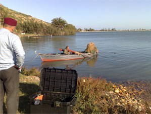
Image 3. The Ghar El Melh coastal area in Tunisia. Photo: Salvatore Carrubba, 2013


