

Integrated Management Plan (IMP) for Bojana/Buna Area
This Bojana/Buna Integrated Management Plan (IMP) is a pilot – “real world” – application of the “Integrated Methodological Framework” (IMF). The IMP helped demonstrate and test to develop an operational methodology for the sustainable management of the ecological continuum constituted by the coastal zone, the river basin, and the coastal aquifer.
The IMP encompasses the transboundary area of Albania and Montenegro, bringing together administrative structures from the two states. The Bojana/Buna River, its catchment, and the underlying aquifers and coastal waters provide the common physical threads linking the two countries. Bringing together International Water Resource Management (IWRM) (including surface water and groundwater management), spatial planning, climate change adaptation, and Integrated Coastal Zone Management (ICZM), the IMP adds value to the individual approaches such that ‘the whole is greater than the sum of the parts’. The experiences from the Bojana/Buna IMP development can be used as reference elsewhere in the Mediterranean basin, including to prevent preparation of separate IWRM and ICZM plans.
The IMP demonstrated, tested, and provided feedback into the plan-making methodology developed under the Integra-tive Methodological Framework (IMF) of the MedPartnership-ICZM component. A joint management plan for the area was developed based on the guidelines of both the ICZM Protocol and the EU’s Water Framework, and refined according to local circumstances. To structure the analysis of the complex interplay between topic areas the "DPSIR" frame-work was used. The IMP was developed over a 5-year timeframe and completed in 2015.
The IMP considers impacts on the coastal zone and the Bojana/Buna basin of upstream activities from the impacts of agriculture, tourism and urbanisation, and marine impacts on the river delta and coastal aquifers. The IMP encompasses the transboundary area of Albania and Montenegro, considering the river basin and coastal zone as a single entity.
Methodology
The Bojana/Buna area is a single natural system extending into two countries, and the transboundary issues and problems addressed reflect the multi-sectoral, integrated nature of the IMP. These issues include the unsustainable spatial development; solid waste and wastewater management; agricultural, fisheries, hunting and forestry practices; and the over-extraction of groundwater and inadequate infrastructure, including flood defences.
These problems are compounded by structural economic weaknesses, including some of the lowest incomes in Europe, weak institutional and technical capacity, and an inadequate policy framework. Upstream pressures include urbanization and land use management, hydropower production resulting to increased flood risk, and pollution. The area has a high vulnerability to climate variability and change, sea-level rise, increasing salinity and extreme events. Transboundary coordi-nation at present is largely ad-hoc.
An Integrative Working Group (IWG) representing the key sectors oversaw the preparation of the IMP. Within the simple 5-Stage Plan Process roadmap defined by the parallel IMF project, the analysis of the complex interplay between issues and problems utilised the Drivers-Pressures-State-Impact-Response (DPSIR) Framework. The DPSIR’s key value was in breaking down boundaries between the IWRM, ICZM, and Coastal aquifer and groundwater management, allowing an integrated approach.
In such a complex policy environment, the analysis of problems and issues does not automatically lead to the “Responses” in a simple linear fashion. A parallel dialogue was required to identify common societal objectives.
To “marry” these objectives to the policy responses, an innovative adaptation of the Bow-tie methodology developed to manage risk, typically in a complex industrial environment, was used. Simply, the method combines multiple ‘causes’ and multi-sectoral responses into a single diagram centred on a set of agreed objectives.
The IMP for Bojana/Buna area affects a terrestrial area of approximately 500km2 drawn using local administrative boundaries, along with the adjacent inshore marine zone comprises approximately half the national territorial waters. The IMP area is thus defined according to guidelines in the ICZM Protocol and the EU WFD, the ecosystem approach, refined according to local circumstances. The IMP area had a total population of over 53.000 in 2011.
The resulting IMP is a multi-sectoral approach, including measures to improve spatial planning, including the economy, water quality, land, flood and waste management, and to maintain biodiversity. The resulting measures are set according to the objectives addressed and the short-term priority actions required to achieve them. In addition, the IMP identifies potential transboundary governance structures to deliver the IMP.
The measures agreed with stakeholders are designed to improve the transboundary governance and cooperation between the two countries; support policy changes at national levels; develop the knowledge base for the management of the system; prevent, mitigate and remediate negative impacts of anthropogenic activities; raise the economic and social well-being of the area's communities; and to increase IMP area's resilience to the impacts of climate change and natural disasters.
Each measure is further refined by the short-term priority actions required to achieve them during the short-term 2015-2020 period, along with success indicators.
The experiences can be used for replication elsewhere in the Mediterranean basin, instead of preparing separate IWRM and ICZM and other sectoral plans. The benefits of this integrated approach are the potentials for win-win solutions, generating economies of scale through shared responses, along with reducing the likelihood of conflict between sectoral interests.
The natural and physical systems of the Bojana/Buna coast do not function exclusively within national boundaries. The integration of management to include the riverine systems was absolutely necessary as the management of the upstream parts is critical to the situation downstream and vice versa.
The Bojana/Buna IMP experience tested the practical realities of defining the coastal zone as required by Article 3 of the ICZM Protocol. The landward boundary was drawn using local administrative boundaries (“competent coastal units”) that broadly conform to the physical boundary of the watershed. The marine zone included a more restricted area of the territorial waters based on a proxy measure of the main influences of land-based activities.
The scoping stage of IMP preparation demonstrated that a realistic period must be allowed in transboundary planning for harmonising data and mapping and for the engagement of stakeholders, and the governance procedures, etc. The Bojana/Buna experience illustrated that in transboundary planning, the support of relevant national governments and unified governance structures are vital, both in the preparation of the IMP and in its future delivery. Clarity of process is vital.
The preparation of the Integrated Management Plan for Bo-jana/Buna helped understand that the ultimate prerequisite of transboundary management of the joint resource are the harmonised data and monitoring procedures. Without same understanding of the process, no constructive measures could be reached. Even though the purpose of this Plan was ultimately to test the methodology its findings could be used to strengthen cooperation through joint actions for the manage-ment of the transboundary area.
REFERENCES
Priority Actions Programme/Regional Activity Centre
(PAP/RAC) www.pap-thecoastcentre.org
marina.markovic@paprac.org
- Lorenzo Paolo Galbiati (lorenzo.galbiati@unepmap.gr)
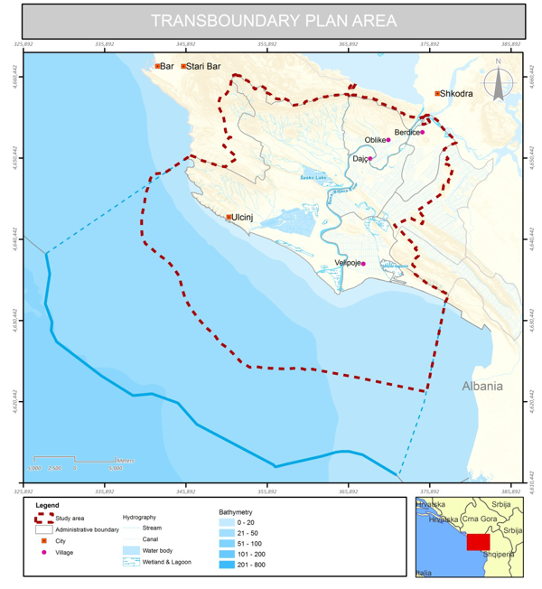
Image 1. Transboundary Plan Area
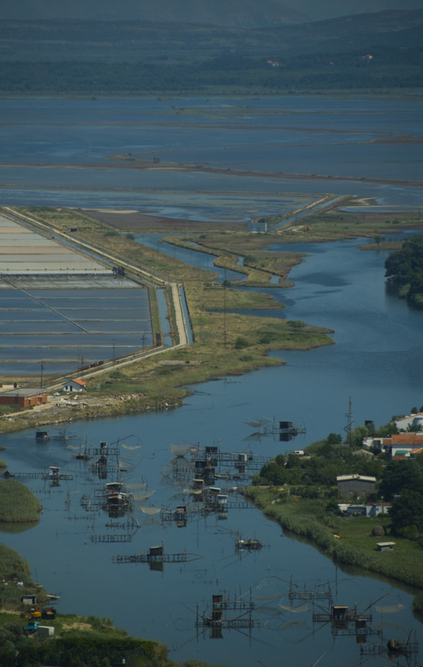
Image 2. Fishing practice on river Buna Bojana Photo: RLC Montenegro


